Document Actions
Explore the watershed
 |
|
|
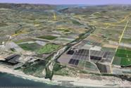
The view from Google Earth. |
Google Earth is free software from Google Labs that allows anyone to view spatial data, including satellite imagery and aerial photography of the entire earth. The application has a built in scripting function that allows users to display their own data as well. Once you’ve installed Google Earth software, the KMZ file linked below will allow you to view the Santa Clara River watershed boundary, stream network, dams, levees and other watershed features. Spatial data from Parkway Floodplain Restoration Feasibility Study investigations are also available through the Watershed Knowledge Base.
To get started: Download and install Google Earth. For best performance, a broadband Internet connection is recommended. To view Google Earth files, click the links below to download and select "open" in the pop-up window (this will launch Google Earth).
Available data sets:
- Santa Clara River Stream and Watershed Boundaries
- Complete Google Earth Data (all of the below)
- Vegetation Alliances
- Arundo Percent Cover
- Historical Flood Mapping
- Focal Species Habitat
- Land Use and Vegetation Types
- Tamarix Presence